Technology category powered by

CyI researchers carry out first-ever mapping of trees and forests in Cyprus using AI
Press Release 12:02 - 17 February 2025

A new study by Cyprus Institute (CyI) researchers presents an innovative tree identification system, via the application of deep learning models on high-resolution aerial photographs.
The research responds to the need for reliable tree counting in Cyprus, which is essential for forest management. Trees contribute to mitigating the long-term impacts of climate change and reducing greenhouse gas emissions. The results of the study significantly contribute to both improving the control and management of forest and urban ecosystems in Cyprus and to strengthening actions to address the growing challenges due to the climate crisis.
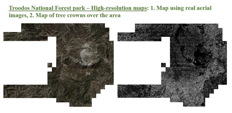
The study was conducted by researchers from The Cyprus Institute’s Climate and Atmospheric Research (CARE-C) and the Laboratory of Climate and Environmental Sciences (LSCE) in France, in collaboration with the University of Copenhagen in Denmark. The study involved the first-ever tree mapping and mapping of forests and residential areas in Cyprus, using a pioneering artificial intelligence model that was adapted and trained by the researchers on the island’s data. Specifically, the model was applied to the Troodos National Forest Park, to count and map almost 1 million trees, as well as to the Athalassa Forest Park, and to a small residential area in Aglantzia, covering a total area of 107 km². Through this process, two detailed maps were created for the Troodos Geopark and the Athalassa Forest Park, with each tree crown recorded with high precision. In addition, the data were used to estimate the total area covered by trees in the Republic of Cyprus.
The study lays the foundations for the creation of the first comprehensive tree registration and mapping in the Republic of Cyprus. Through the processing of these results, it will be possible to examine important parameters, such as the consequences of forest fires, the exact location of burned areas, and the analysis of endemic tree species in the mountains of Cyprus. It will also provide useful information to foresters and other government agencies for taking appropriate measures, such as tree planting and reforestation of burned forest areas. Additionally, through this research, the total forest biomass and the biomass of individual trees will be calculated with high precision for the first time in Cyprus. This will allow the estimation of the total carbon absorbed by trees and will significantly contribute to the implementation of the objectives set by the EU for the reduction of carbon dioxide emissions in order to address the climate crisis.
This research was carried out within the framework of the Horizon Europe Edu4Climate program, which is funded by the European Union.
-------------------------------------
Publication: Zenonos, A., Li, S., Brandt, M., Sciare, J., & Ciais, P. (2025). AI-powered estimation of tree covered area and number of trees over the Mediterranean island of Cyprus. Frontiers in Remote Sensing, 6. https://doi.org/10.3389/frsen.2025.1498217
News Feed

2 hours, 43 minutes ago Companies
Cyprus’ cruise season kicks off as Marella Discovery II sets sail from Limassol3 hours, 22 minutes ago Financial Services
Banking sector profitability declines by €47m to €1.215b in 20244 hours, 38 minutes ago Current Affairs
Honorary Consul of the Philippines in Cyprus attends CSW694 hours, 59 minutes ago Technology
Four out of five internet connections in Cyprus at a speed of 100Mbps or higher5 hours, 14 minutes ago Companies
Enjoy Easter with the most EPIC offers – €200 discount on smartphones at Epic6 hours, 28 minutes ago Current Affairs
European travellers need €12 entry permit to visit the UK starting today7 hours, 14 minutes ago Economy
Cyprus' air connectivity strengthened with new destinations and bolstering of existing routes